 Two weeks ago, we headed up to Leavenworth for the weekend. Leavenworth is quirky little town filled with Bavarian facades—very touristy. But it put us close to the Colchuck and Stuart Lake Trailheads for an early start on Sunday. Leavenworth also provides a strong offering of sausages for pre-hike dinner.
The trailhead was a 45 minute drive from Leavenworth. We hit the road about 6 am. Fortunately the Leavenworth Starbucks opens early.
 The drive was mostly on hardtop roads. The last 3 miles or so took about 20 minutes to drive—a climb along a curvy, washboard gravel road. Colchuck and Stuart Lakes are part of the Alpine Lakes Wilderness and require a Northwest Forest Pass. Colchuck Lake is quite popular, in part as it’s en route to the Enchantments. Even at 7 am, the parking lot was nearly full.
Overnight camping requires permits, which are given out by lottery. Day use is open, but you need to grab a green tag at the trailhead. One part goes in the box, the other on your pack.
The trail starts out wide enough for two or three people. It parallels and periodically crosses a large, crystal clear creek.

Mountaineer Creek
The trail starts at 3400 ft elevation and climbs gradually to 5600 ft elevation over 4.5 miles. There are several breaks in the trees so you can get a preview of the peaks as you head up to Colchuck Lake.

 Over this part, the trail is mostly hard pack dirt with some gravel, with a short section crossing boulders. We spotted an adult and juvenile pair of mountain goats. We kept our distance, since they can be aggressive.

GOATS
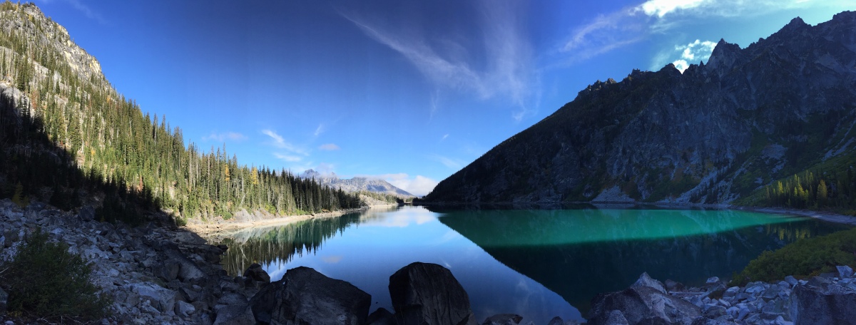
The first 4.5 mile stretch brought us to Colchuck Lake. The views were amazing: a large placid lake with razor topped peaks, Dragontail Peak, rising behind.


Colchuck Lake & Dragontail Peak
There was also a small lake adjacent to Colchuck Lake, unnamed as far as we know.
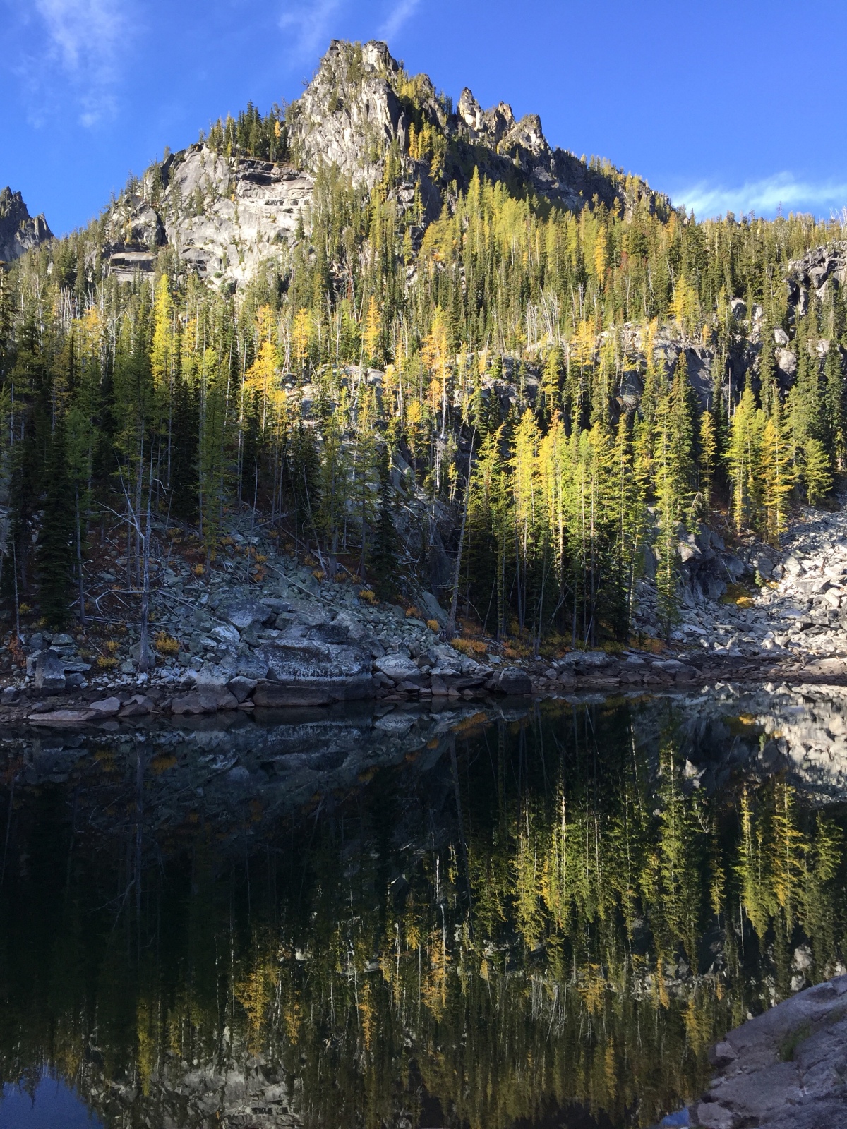
The lake with no name
The trail then continues next to the lake, running pretty flat for the next mile. Leaving the forest behind, you reach a field of large boulders. At this point, there’s no clearly defined path. Instead there are cairns that provide points for navigating across the field. It takes a good bit of balance and mobility to cross this section, as there are often deep gaps and holes between the boulders, differing surface levels, etc. There’s a fantastic scene from the beach on the upper end of Colchuck Lake.
Colchuck Lake
After the boulder field comes the climb to Asgard Pass, the entry to the Enchantments. There are a few defiant copses of trees growing on the granitic mountain side, nothing to provide any substantial cover for those venturing up. But with the peaks rising sharply ahead, from 5500 ft at Colchuck Lake to near 9000 ft elevation, the mountain itself provides shelter from the sun for much of the climb.
Here the trail is really only wide enough for single file and becomes a bit difficult to follow, even with the wayfinding cairns. Since the trail was busy, we could sort of follow other folks. But there were short sections with multiple options. A pair of forest rangers were taking the trail part way up to do some cliff climbing. Along the way, they checked permits, chatted with trail users, and on one occasion directed a cluster of hikers toward a better portion of trail.
The trail fades more as you near the top, becoming more rock and boulder than gravel and sand. It nears, then crosses and parallels a small stream trickling down the peak. Now you have to watch for ice and frost in addition to loose footings and trip hazards.
We could look back and see how far we’d come up. We could look up and see the peak still towering above us, though now a few streaks of direct sunlight broke through blinding. The ascent gets steeper. In one place, we had to clamber up a split granite mound, leveraging limbs against vertical faces and pulling the body up and over the top (or getting a hand from someone above).
It felt as if there couldn’t be much further to go. But at some point, it felt as if we just weren’t getting closer to the top, no matter how much we climbed. As groups crossed more challenging sections, someone would inevitably call out, “That’s the hardest part!” The “hardest part” kept getting unseated by the next “hardest part.” Add to this, we were now more than a mile above sea level, our bodies working hard under the physiological challenge.
The going was slow and becoming more difficult. We didn’t want be racing daylight, and we knew that down didn’t mean easy. The 7.5 miles or so (which we’d expected to be 6 miles) had taken us 4-1/2 hours to complete. I was increasingly nervous about the technical components of the trail and how challenging they’d be coming back down. And Gene’s hip injury wasn’t entirely resolved. We still had done a hard thing, climbing 2000 ft up from Colchuck Lake, rewarded with an incredible view. So we called it a day before we reached the peak and started (attempting) to retrace our path back down the mountain. (We checked later—”almost there” was still another 400 vertical feet to the pass. Considering how long it’d taken us to get that far, we made the right call.)

The descent was quieter than the ascent. Most on their way up were doing the through-hike, and by this time of the day, the upward bound traffic was beginning to thin. The path was even more difficult to follow on the way down, and it was easy to find ourselves 10s or 100s of meters from the “trail”, leaving us to scramble over boulders to try to rejoin the path others had taken. It was steep and we took a lot of low-to-the ground, three-point maneuvers to mitigate the risk of 6-24 inch drops off rocks and boulders, sometimes onto loose soil. Shortly after the turnaround, Gene felt a “pop” in his left quad 😬
But it wasn’t all nerves and misery. The view ahead of us, when we’d pause for a glance, was incredible. We spotted a large mountain goat, a safe distance away, grazing on a stretch of flora.

Pika says “eep”
I was also thrilled about the number of pika scurrying about the boulders. On the way up, we’d noticed this “eep” sound around us. Gene said something about a bird. But as we made our descent, we spotted a pika on the end of a boulder, shouting “eep eep eep”. We paused to watch the critter bounce across the rock field. Our little shouty friend disappeared but soon was coming straight at us with a stem full of leaves as big as it was. It paused just inches away, stared down Gene, then darted right between us, so close the leaves it carried trailed across my fingers that were resting on a rock.
The going got easier back lakeside, as the trail leveled out and became easier to follow again. We made another quick stop at Colchuck Lake to take in the view again before making our way back to the trailhead.


One regret: not finding the toilets at Colchuck. Because the trees are tall and skinny, needles on higher branches, it was nigh impossible to find a discrete place. The stretch between Colchuck and the trailhead was heavily trafficked, so I was very much feeling this cartoon.

We finished the hike exhausted and hurting a bit, more than 9 hours after we started. But it was worth it.


[…] for a month or so. I, on the other hand, have had several setbacks. As Melissa wrote in the Lake Colchuck recap, I felt my quad pop on the descent from Aasgard. I was able to make it down, obviously. The whole […]
LikeLike
[…] the gym, but it was challenging. Then, once I was running again, I tore my quad on our hike up to Lake Colchuck, And couldn’t do anything for almost a week. After that I had just gotten back to running […]
LikeLike
[…] 22 is one of Washington’s most famous alpine lakes. It ranks up there with Lake Colchuck for drama, beauty, and crowds. It’s much closer to Seattle that Colchuck is, and the approach […]
LikeLike