It’s easy to get caught up in the grandeur of the Cascade Mountains here. But one of the cool things about Seattle is trail(ish) running options within the city limits, nestled right in the midst of popular neighborhoods. They might be small, but some pack a pretty good vertical punch for their size.
We really started taking advantage of these options late this summer as we recovered from injuries. When my PT gave me clearance to start running again, it was with a “trails only” stipulation. So I started exploring the options I could get to via a short bike ride. Gene and I also used these options as we started to stretch distance back out but needed to respect what our bodies were telling us in real time.
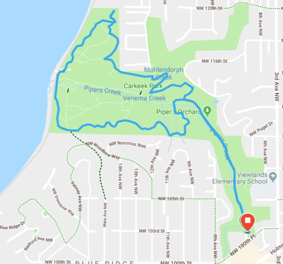
Carkeek Park is a wooded ravine bordering Puget Sound. It’s about 220 acres sitting not far north of Ballard, with a small network of trails running through woods and wetlands. None of the trails are what I would (now) consider technical. They’re mostly dirt with a nice leaf and needle layer this time of year and generally a bit wider than single track. Steep climbs come in the form of stairs.
There are certainly gentler options, but by trial and error exploration, I worked out a lollipop course that hits right at 3.3 mi and 700 ft elevation gain. About half the gain comes in 3 short, steep (10-15% grade) bursts. Another bit comes in a half mile section at about a 3.5-4% grade. The rest is a rolling run.
There a couple of different access points and a small network of trails weaving through the park. The main entrance for the park is off NW Carkeek Park Road, which is suitable if you’re in a car. But that takes you down into the ravine through curves with no shoulder—not a great route if you’re on a bike. So our course starts from the entrance off NW 100th Place, the south access to Pipers Creek Trail.
There’s a bench and a couple of signs that you can secure a bike to. There’s a small parking lot with about a half dozen spaces and space along the curb for maybe as many more.
 You can check out a trail map and pick up a paper copy at this entrance—just keep in mind that a small section of our loop isn’t marked on those maps yet.
Getting started from here is easy. There’s only one way to go—down the wide gravel path, Pipers Creek Trail. As the trail disappears into the trees, the grade steepens with a couple of switchbacks. But the path remains wide and non-technical. You drop about 80 ft in the 0.1 mi, followed by a more gentle descent of about 100 ft over the next half mile.

Piper’s Orchard
Pipers Creek Trail is relatively well traveled by runners, bikers, and people out for an easy stroll, many with dogs (or even a cat on a leash). As you descend, you’ll cross Pipers Creek a few times, always on wide foot bridges. You’ll pass a trail spur, marked with laminated paper as Viewlands Trail; this takes you back up to the city streets, so keep padding along Pipers Creek Trail. You’ll also pass by a small orchard, complete with apple trees.
A little past the orchard, you’ll pass another trail to the right, which doesn’t appear on the park’s maps or AllTrails (though it is in Google Maps). This is where you’d turn to take the loop counterclockwise. But to go clockwise, as I’ll describe here, keep going a little further.
You’ll approach a clear fork in the trail with a brick building to the right (this is a pump station and sewer overflow treatment facility. Turn left for your first short climb up South Ridge Trail.


When the trails fork in Carkeek, they’re usually clearly marked with posts and green signs with the names and directions of the trails. As options present themselves, stay on South Ridge Trail through to South Bluff Trail. As South Bluff Trail turns to the right and runs parallel to the sound, you’ll descend a long set of stairs back to sea level.


After running next the railroad tracks a short distance, you’ll come up a short set of stairs to one of the main areas of Carkeek Park with parking, picnic tables, and a playground. Here you have an unobstructed view of Puget Sound with the Olympic Mountains in the background. (If you’re so inclined, you can detour across the pedestrian bridge over the railroad tracks to the beach.)

To continue the loop, stay on the path by the parking lot, then past the cement circle and back into the woods and up the hill on North Bluff Trail.


Follow North Bluff Trail to the North Meadow.

 Make a loop around the big fir tree to make the top of the knoll. (If you’re here during summer, you’ll find fresh blackberries just beyond it.) Then head back down the hill.
You’ll reach a fork where the path continues naturally to the right, which would take you back the way you came. Instead turn left down the stairs (North Meadow Hillclimb) then soon another left onto Grand Fir Trail.
Before long, it’s a sharp left on North Traverse Trail. Not far beyond is one of the few unmarked turns of the trail. The trail curves right and you can see it leading down to the road. With a leaf covered forest floor, it can appear as if that’s the only option. But behind the big, twisty, knotty tree, North Traverse Trail continues to the left, running above the road.


At the next trail fork, turn right to head down the 12th Ave Hillclimb to the drive through Carkeek. There’s a well worn path along the edge and the next trails are just around the corner.
Follow the stairs up and then the path through the educational garden and behind the Educational Center. Cut through the parking lot and across the drive way to find the top of the unmapped bit of trail.


Once you’re down the stairs, the trail flattens back out and rejoins Pipers Creek Trail. Turn left and head back to the start.
Reversing the loop is pretty straightforward after you’ve run it a time or two—and gives you a different experience of the course. I’ve gotten up to 13+ miles on this loop in one go. I’ve typically avoided loops like the plague, but the variety of the trails makes a big difference.
Carkeek Lollipop on Garmin Connect
How do you handle routes when returning from injury?
Do you love or hate loops?
Have you found “hidden gems” of small trail networks near you?
